And it's the end of September, 2008. Posts will begin to look familiar from those of late last year. That's right. It's time for serious work to begin on Christmas lights.
As it stands right now, as of 1:27 AM on Tuesday, September 30, 2008:
Days Until Lights Start Going Up: 32
Days Until Lights On: 58
Days Until Christmas: 86
Last Night For Lights: 92
It won't be long. Oh, and last year there were 29,998 lights not including strobes. This year, I'm making damn sure that we top 30,000!
Tuesday, September 30, 2008
Friday, September 12, 2008
Something to Think About Today
Here's a nice quote to remember:
"Time lost can never be recovered, and this should be written in flaming letters everywhere."
Another thing to think about:
Those who forget history are doomed to repeat it.
I bring these two things up today for a reason. The quote at the top was spoken by Isaac Monroe Cline. Isaac was born in Tennessee, and passed away August 3, 1955 at the age of 93. Though he grew up on the farm, he became a meteorologist, and found his way to Galveston, Texas in the late 1800's. He was the one in charge there when on Saturday, September 8, 1900, a Category 4 Hurricane came roaring ashore just west of town. It started out a nice day. The ocean was large, but the sky was a beautiful shade. Even with warning of an impending storm, nobody left.
Right now, Friday, September 12, 2008, there is a very dangerous high-end Category 2 Hurricane in the Gulf of Mexico heading right for Galveston. At the very last minute, mandatory evacuations were issued for the island. We shall see how this turns out. We can only hope that it turns out better than 1900.
8,000 people were killed in the 1900 Hurricane. One of those killed was Isaac's wife, Cora. Isaac never remarried after that.
Saturday, September 6, 2008
And the Contest Results Are In
And the winner is...
Dad!
There's a reason he's smiling...he got the landfall point right!
Dad!
There's a reason he's smiling...he got the landfall point right!

Here I am, hanging my head, playing a sad song, because I lost. Oh well. Off to bed for the night...it's been a long one. I'm going to Charleston to play music tomorrow! That will be fun. And I'll get to meet Joey's new baby girl.
Tropical Storm Hanna Makes Landfall
3:35 AM Saturday, September 6, 2008 now. Hanna has made landfall right on the SC/NC border. Here are radar grabs from landfall:


Time To Concede
It is 3:20 AM now, and though Hanna is not yet officially onshore, she is close enough for me to have to concede, and admit loss in the contest with dad on where she will make landfall. She is minutes away from landfalling, and is right at the SC/NC border.
Here are the graphics:
Wilmington:
 Newport/Morehead City:
 Wilmington Long Range:

Here are the graphics:
Wilmington:
 Newport/Morehead City:
 Wilmington Long Range:
A Snip From The 2:00 AM Advisory
AT 200 AM EDT...0600Z...THE CENTER OF TROPICAL STORM HANNA WASLOCATED JUST OFFSHORE NEAR LATITUDE 33.3 NORTH...LONGITUDE 78.8 WESTOR ABOUT 30 MILES...45 KM...SOUTH OF MYRTLE BEACH SOUTH CAROLINAAND ABOUT 60 MILES...95 KM...SOUTHWEST OF WILMINGTON NORTHCAROLINA.HANNA IS MOVING TOWARD THE NORTH-NORTHEAST NEAR 21 MPH...34 KM/HR. THIS MOTION IS EXPECTED TO CONTINUE DURING THE NEXT SEVERAL HOURSWITH A GRADUAL TURN TO THE NORTHEAST AND AN INCREASE IN FORWARDSPEED TODAY AND TOMORROW. ON THE FORECAST TRACK...THE CENTER OFHANNA WILL MAKE LANDFALL NEAR THE BORDER BETWEEN SOUTH CAROLINA ANDNORTH CAROLINA WITHIN THE NEXT COUPLE OF HOURS...THEN MOVE ACROSSEASTERN NORTH CAROLINA LATER THIS MORNING...ALONG THE MID-ATLANTICCOAST LATER TODAY AND TONIGHT....AND ALONG THE COAST OF THENORTHEASTERN UNITED STATES AND SOUTHEASTERN CANADA ON SUNDAY.
It appears as though Dad has won the contest. It will not be official until the center officially makes landfall, though.

It appears as though Dad has won the contest. It will not be official until the center officially makes landfall, though.

1:30 AM Contest Update
Hello again. Tropical Storm Hanna continues to move. Thus, we will post another update to the Dad and Kenny Landfall contest. Since Hanna is continuing to move northward, another radar site has been added from the Morehead City area. It appears as though a very slight shift in movement has occured. Thus, it also appears that I may be in a bit of trouble contest-wise.
Charleston:
Charleston:

Wilmington: Newport/Morehead:
 Wilmington Long Range:
Another Hanna Update
It's time for another update. I've been watching the reports on WPDE news. About 10,000 people in Myrtle Beach are currently without power. There is a large tree down on 29th Avenue North. Also, several spots along the Grand Strand the surge (we just passed high tide, so it was even higher) has come up past the dunes and is flooding some of the lower areas of the back properties of hotels.
Another Update
Just received a phone call from my sister (she calls herself "Fondueprincess" for her blogging name) in Myrtle Beach. They just lost power down there.
The power has been flickering here for about the past 15 minutes, but so far we are still up and running.
The power has been flickering here for about the past 15 minutes, but so far we are still up and running.
Friday, September 5, 2008
Contest Update
OK. Here is the midnight update on how we are doing with the contest. Hanna continues to make her way toward the coast. Who's winning? So far, it's still up in the air. We'll find out more as the night progresses. Here are the current graphics depicting our landfall locations:
Charleston Map:
 Wilmington Map:
 Wilmington Long Range:

Charleston Map:
 Wilmington Map:
 Wilmington Long Range:
No Upgrade
The 11:00 PM NHC advisory is in. No upgrade. We have a 70 mph Tropical Storm Hanna. She has a pressure of 978 mb. Wow! That is a LOW pressure for a Tropical Storm. They still have her moving north. She is moving more north now than she was earlier. Stand by for an update on the landfall contest.
The Contest is ON!
So dad and I were talking earlier tonight about the track and movement of Hanna. I was explaining to him that it was moving slightly west of due north, and further west than thought. I also told him that a couple of days ago, on my Facebook profile, I made a call for a landfall of a Hurricane between McClellanville and Georgetown. Dad is going with the NHC forecast of a SC/NC border or Brunswick County, NC landfall as a Tropical Storm.
We'll see. Here is a graphic of our thoughts and the current (as of this posting) center location:

We'll see. Here is a graphic of our thoughts and the current (as of this posting) center location:

More Radars
Want to track "Hurricane" Hanna through the Carolinas and beyond? Here are some local and long range radars that you can do that with. First I will post "Static Image" radars, then below them will be the animated radars. The long range only has animated available. I will post it at the top.
Click on the picture to get a larger image.
As Hanna moves north, I will post radars farther up the coast so her progress can be watched.
But for now...
Here's Hanna:
Wilmington Long Range Animated:

Animated:

Columbia, SC:
 Animated:

Raleigh/Durham, NC:
 Animated:

Blacksburg, VA:
 Animated:
Newport/Morehead, NC:
Static:
 Animated:
Click on the picture to get a larger image.
As Hanna moves north, I will post radars farther up the coast so her progress can be watched.
But for now...
Here's Hanna:
Wilmington Long Range Animated:

Inland Radars:
Robbins AFB, GA:
Static:
Animated:
Greer, SC:
Static:
Animated:
Columbia, SC:
Static:
Animated:Raleigh/Durham, NC:
Static:
Animated:Blacksburg, VA:
Static: Animated:
Coastal Radars:
Charleston, SC:
Static: Animated:
Wilmington, NC:
Static:
Animated:Newport/Morehead, NC:
Static:
Animated:Wakefield, VA:
Static: Animated:
Hunters find a Hurricane
And just in time to MISS the 8:00 PM Advisory.
The Hurricane Hunters flying around in Hanna found a maximum surface sustained wind of 65 kts, which converts to 77.1 mph. This makes Hanna a Category 1 Hurricane. She will either be officially upgraded at the 11:00 PM advisory, or the NHC MIGHT issue a special advisory based on these findings. We will see.
The Hurricane Hunters flying around in Hanna found a maximum surface sustained wind of 65 kts, which converts to 77.1 mph. This makes Hanna a Category 1 Hurricane. She will either be officially upgraded at the 11:00 PM advisory, or the NHC MIGHT issue a special advisory based on these findings. We will see.
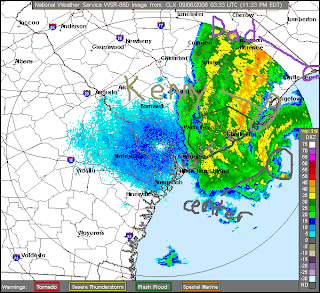
Hanna in the Area
Here is a radar capture of Hanna in the Coastal Carolina area. She is currently a 70 MPH Tropical Storm on her way to landfall near the SC/NC border. She may still make it to minimal Category 1 Hurricane status before striking land. For reference, I'm located in Conway, SC, which is located inland up Highway 501 from Myrtle Beach, in Horry County.
Subscribe to:
Posts (Atom)